
Railway Board Junks its Alignment Methodology to Adopt the Engineer’s Methodology
After opposing for many years the alignment methodology developed by Alok Kumar Verma, Retd. IRSE for the Kashmir Rail Link, Railway Board has finally junked its methodology. Faced with a particularly formidable terrain in Manali-Leh section of the line to Leh, Railway Board approved in 2017 an alignment based on Verma’s methodology for Final Location Survey of the Ladakh line. But, this alignment ignores the most important aspect of Verma’s methodology: addressing the various geohazards (including high altitude of 2,500 to 5,000 m between Manali-Leh) that are present in the Himalayas.
Verma made a detailed post on Twitter on this alignment on 24.08.2020. The Northern Railway officers incharge of the survey met Verma and sought his suggestion for improving the alignment.
Verma conveyed his suggestions on 12.10.2020. Recently, he has written two posts on Twitter about his suggestions to Northern Railway and wrote that it is essential that Railway quickly build up a knowledge base to tackle the unique terrain and geology of the young Himalayas.
Besides the importance given to geology and terrain, the main features of Verma’s methodology are as follows:
- Steep gradient of up to 1 in 30
- Tunnels laid deeper into the mountain ridges
- Small bridges and cuttings.
- A straighter and shorter alignment compared to a typical alignment in other mountains
I. THE ALIGNMENT APPROVED BY RAILWAY BOARD FOR THE FINAL LOCATION SURVEY:
Verma wrote: “On the rail line to Leh, Railway Board risks its biggest misadventure in the Himalayas. The alignment that Railway Board has approved for final survey and DPR is a unworkable alignment on which construction of a Broad Gauge (BG) line from Manali to Leh is not feasible.”
He says, “This alignment is worse than the alignment for the 106 km long Katra-Banihal Kashmir Rail Link where Indian Railways is struggling to build the line for the past 18 years and INR 457 crore is slated to be spent on this survey.”
He said there should be no illusions that a BG line from Manali to Leh, if ever built, will be the most difficult mountain railway ever: “More difficult than the Qinghai Tibet Railway (high altitude of 4,000 to 5,000 m, and permafrost); the Sichuan Tibet Railway (high-relief mountainous terrain at high altitude of 3,000 to 4500m), which is under construction; and the line from Tibet to Kathmandu (Partly high elevation and partly high relief mountainous terrain) that China is considering.”
Like the Sichuan-Tibet line, the terrain that the Manali-Leh line shall cross is a high-relief, high-elevation mountainous terrain but with higher elevations:
“The highest elevation on the Sichuan Tibet line is 4300 m, but the Manali Leh line will reach 5,000 m. Some satellite images of the terrain in this subject can be seen.”
What makes this alignment unworkable are the numerous long tunnels (up to 27 km long) that are required to be built in a very adverse high relief mountainous terrain in high altitude zone of 3000-5000 meters above MSL. It is extremely difficult to build tunnels at altitude above 3000 m, and nowhere in the world has anything at this scale been ever attempted.
Currently, the world’s longest tunnel at elevation above 4,000 m is the 1,338 m Fenghuoshan tunnel, which is situated at 4,905 m above sea level on the Golmud-Lhasa line in China.
The other important features of the alignment under final survey are as follows:
THE ELEVATIONS:
Total length from Manali to Leh is about 324 km. The line to Leh will have to climb from 2000 m elevation at Manali to 3500 m at Darcha in about 80 km length, then it will run for 275 km in high elevation zone reaching maximum elevation of 5000 m before terminating at Leh at 3200 m.
THE TUNNELS:
Three tunnels are longer than 20 km, and five are 10 to 20 km long. The following 3 stretches are almost entirely in tunnels:
- Km 138 to 262, 124 km: 117 km in tunnels, 94%
- Km 281 to 313, 31.4 km: 30.7 km in tunnels, 98%
- Km 350-396, 45.2 km: 38 km in tunnels, 84%
Such long stretches continuously in tunnels on a single line will be acutely problematic for safety and operations, particularly the arrangements for rescue and relief in this remote, uninhabited and inhospitable region.
One station will be fully inside tunnel, and two will be partly in tunnels. Some stations are 20 to 35 km apart, which together with low maximum speed of 75 kmph will seriously impair line capacity.
For constructability, particularly problematic are five very long high-altitude tunnels given in the table below:
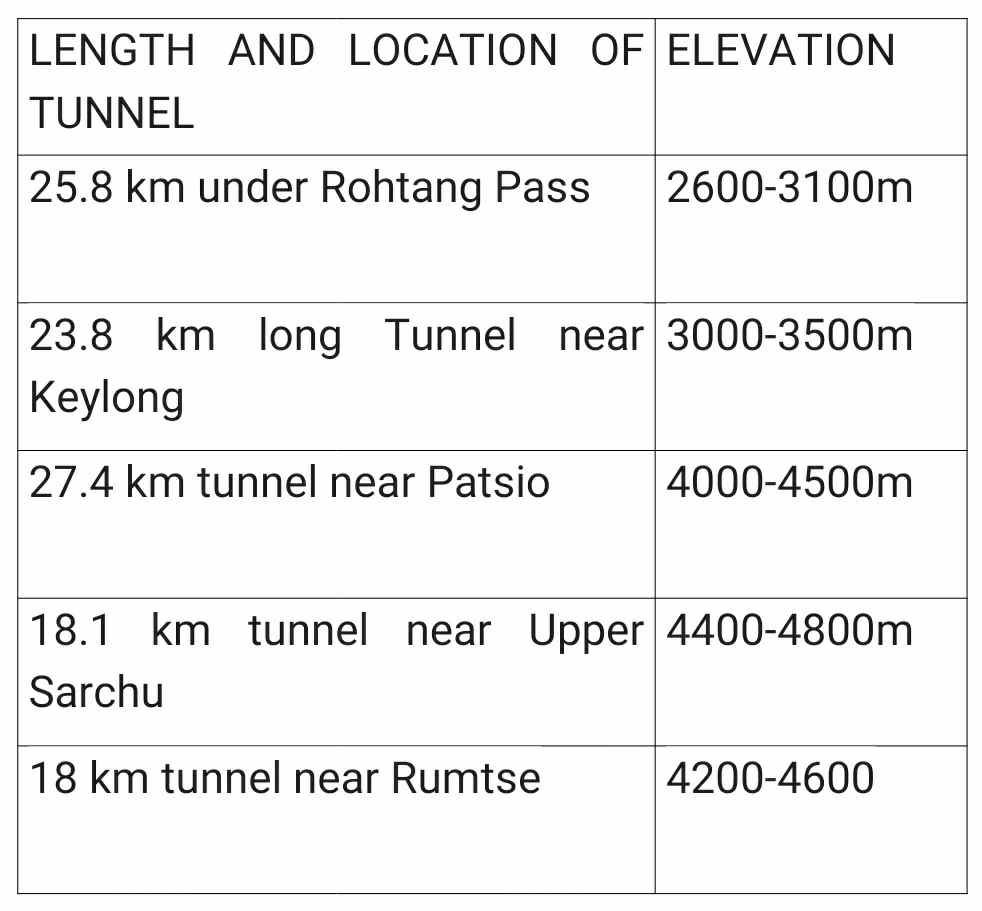
LENGTH AND LOCATION OF TUNNEL ELEVATION
- KM 25.8 under Rohtang Pass
2600-3100m - KM 23.8 long Tunnel near Keylong
3000-3500m - KM 27.4 tunnel near Patsio
4000-4500m - KM18.1 tunnel near Upper Sarchu
4400-4800m - KM 18 tunnel near Rumtse
4200-4600
Large bridges and high embankments / cuttings could also be very problematic, if affected by permafrost.
The following are the main reasons for the extremely poor constructability in the 275 km long high-altitude zone on this alignment:
- High altitude sickness among workers and drastically reduced output and performance due to less oxygen in the air.
Working season of less than 6 months. -
Long distances in a remote, inhospitable region and poor condition of the Manali-Leh highway.
-
Very sparse human settlements with barely few thousand people living in this zone.
-
Permafrost ground above 4000m: The problem of permafrost in the Himalayas for stability of roads and buildings is yet to be studied.
“Has Railway studied likely effects of permafrost ground on construction of the railway tunnels, bridges/viaducts, and embankments / cuttings, and the impact of rise in temperature, higher rainfall due to the Climate Change in the next 20 years?”
Undoubtedly, the above 5 very long tunnels (together with the other long tunnels and bridges) at high altitude render this alignment unworkable.
Railway has reported estimated cost of the Bilaspur-Leh line as INR 83,360 (based on 2018 prices) which is a gross under estimation.
Whereas Mr Verma estimates that at the current prices the cost of construction of the line will be INR 1,30,000 to 1,50,000 crore.
Alternative alignment as per Mr Verma’s methodology that takes into account the geohazards also: “he has prepared a rough conceptual alignment using the methodology which he developed for the Kashmir Rail Link Project.” The Main features of this alignment are as under:
- It is shorter by about 60 km. The longest high-altitude tunnel will be about 12 km
- Highest elevation reduced by about 400m
- It will be a double line with station spaced at 40 to 60 km with non-crossing Halt stations in between
- Speed 160 kmph
- Ruling Gradient – 1 in 35
Cost of construction – About 20% less than single line on the approved alignment for Final Location Survey.
Construction time – About 15 yrs.
However, considering the high cost and long period of construction, the Government should consider building this line on Meter Gauge (MG). The line on MG will be shorter with shorter tunnels and smaller bridges, and it will cost one half to one third the cost of a BG line and can be built in about 8 years.
He say, “I have not covered the Bhanupali-Bilaspur-Manali portion but it will also be cover later. The alignment in this portion is a slope-skirting alignment, mostly in cuttings and embankments. It is as bad as the Kashmir Rail Link alignment with very poor constructability, impaired stability of the line, and high risk to safety of trains.”
“This shows Railway has deep rooted systemic problems that make it incapable of making workable alignments for the challenging Himalayan terrain,” he said.
II. NORTHERN RAILWAY’S CONSULTATION VERMA EXPERT AND HIS SUGGESTIONS
On 28.09.2020, Chief Engineer, Northern Railway incharge of the above survey came to Verma’s residence with five other engineers to discuss the alignment and sought his suggestions. Mr Verma wrote:
“It was in the midst of the Coronavirus Pandemic so we discussed the matter in a nearby conference room facility where we could keep necessary social distancing. The discussion on that day stretched over about seven hours.”
The engineers of Northern Railway also gave a presentation on their alignment and later sent him detailed alignment maps and other documents which he wanted to examine further before he could formulate his suggestions.
Mr Verma sent his suggestions on 12.10.20 by email.
Before he made the aforesaid post on the alignment on 24.09.20, he spent about two months to examine the entire 460 km long alignment and familiarised himself with the terrain and geology of the region and technical issues that would be involved in survey, design, and construction of a railway line at such high altitude of 3,000 to 5,000m above MSL.
He has laid emphasis on severe health effects of engagement in construction of tunnels, bridges and embankments/cuttings, and other components of the line infrastructure at high elevations. He says he has tried to cover all the above issues atleast briefly in his suggestions.
For details of his suggedtions please see his post on Twitter @trains_are_best for which link is given below:
BILASPUR – MANALI – LEH RAILWAY: NORTHERN RAILWAY'S CONSULTATION WITH ME AND MY SUGGESTIONS
.. 1/3 https://t.co/YeUG3YfrPD pic.twitter.com/zHt3QFfQsT— Alok Kumar Verma, IRSE (Retd.) (@trains_are_best) February 19, 2021
III. THE WORK CULTURE OF SURVEYING FOR RAILWAY LINES ON INDIAN RAILWAYS THAT HAS TO CHANGE
Verma has one more observation for Railway Board which he made in his last post:
Indian Railway must quickly create a base of knowledge and skills concerning survey, design and construction that are needed for building railway lines in the uniquely challenging terrain of the Himalayas.
The present reliance on foreign consultants has serious limitations. This he has seen in about fifteen years of his extensive involvement with the ongoing seven new line projects of Indian Railways in the Himalayas in Kashmir, Uttarakhand and the Northeast states.
There are two main reasons why this exclusive reliance on foreign consultants does not work:
- The unique terrain and geology of Himalayas which is quite unlike the other major mountain ranges of the world.
-
The tendering system which rewards the party which quotes the lowest cost for their services.
If a foreign consultant were to really study everything in detail with adequate site visits and put it’s best engineers on the job, and their cost would be very high.
Due to the above factors, Indian Railway has not been able to bring the best consultants for the job, and this is the main reason why so many problems have been faced on the above mentioned projects in the Himalayas, particularly in regard to preparing the alignment and design of unique structures like the mega arch bridges, record height beam-girder bridges, huge cuttings and tunnels.
Invariably these structures were located in highly stratified rocks near the geological fault lines and other discontinuities and are also exposed to the various other geohazards which are present in the regions of Himalayas where the lines are being built.
The most important phase of construction is ofcourse the part concerning survey and preparation of alignment. With a good alignment many of the aforesaid problems can be overcome to a large extent.
He further said, “In 2005-08, he had developed a new alignment methodology for building the Kashmir Rail Link, which the Sreedharan Committee had unanimously recommended in 2015 should be adopted in place of the existing alignment. This methodology has wider applicability and can be adopted for building lines in almost all regions of Himalayas.”
The Sreedharan Committee had also made mention of the wider applicability of his alignment methodology developed in its report on the Kashmir Rail Link.
By adopting an experts’ methodology, will Railway Board be able to come up with a workable alignment?
“A lot will have to be done”, but doubts if Railway Board has the patience for that. This new methodology is not just about drawing an alignment with steeper gradient. So first of all, a team of engineers has to learn the methodology fully. That will not be easy. They will have to study his reports, file noting and presentations, and the reports of both Ravindra & Sreedharan Committee.
These engineers will have to acquire knowledge of basic engineering geology and the various geohazards in Himalayas as they apply to survey design and construction of railway lines, including geological mapping and techniques of ground investigation, and basic elements of geological design. Also, they will have to familiarize themselves with the uniqueness of the Himalayan terrain and rock formations through extensive field visits.
For the team, Railway Board will have to bring engineers having some background in design & construction of tunnels, bridges & cuttings/embankments, landslide & earthquake engineering, slope stability analysis & the methods of stabilizing slopes.
So far, Indian Railway has been delegating first and third above entirely to consultants, but that does not work. Alignment making is both a science and art. This job of creating the initial knowledge base and skills will take about one year. Thereafter, preparation of alignment with necessary ground investigations could take 18 to 24 months for the Bilaspur-Leh line.
Presented by: Surresh Tripathi
Alignment Methodology for lines in Himalayas
Somebody asked me:
By adopting my methodology, will Railway Board be able to come up with a workable alignment?Yes, but a lot will have to be done. I doubt if Rly Bd has the patience for that.
First, this new methodology is not.. https://t.co/ruofIjxsOh pic.twitter.com/0Vl3pzzzWO
— Alok Kumar Verma, IRSE (Retd.) (@trains_are_best) February 24, 2021
#BilaspurManaliLehRailLine #PMO #PMOIndia #RailwayBoard #railway #RailMinIndia